2.1 Regional Hydro-Climatological Features
The inhomogeneity of the relief structure causes Central Asia to be the territory of immense contrasts. Here, extreme aridity in the hot deserts of the plains and, only 100 km away, abundant humidity and snowfields in the mountains where precipitation levels can range between 1’000 mm up to 2’000 mm. The uneven distribution of water bodies is striking. The mountains of Central Asia are riddled with an extremely branched river network consisting of more than ten thousand watercourses. In the flat foothill areas surrounding the mountain ranges, another branching river network is found which consists of irrigation channels, which do not contribute to the runoff of the core rivers, but rather divert the water from the river network and diffuse it in the irrigated oases where much of it gets evapotranspirated.
Central Asia is spreading over approximately 4 million km2, including the territories of Kazakhstan, Kyrgyzstan, Tajikistan, Turkmenistan and Uzbekistan (Central Intelligence Agency, n.d.). In the vast plains that cover around 70% of the total territory, there are only very few rivers which have scarcely any tributaries from the point they leave the mountain areas all the way to their mouth. Abundant solar radiation, high temperatures, small amounts of precipitation, a lack of humidity, unstable snow cover, slight slopes, geological structures2, etc., hinder the formation of surface flows in the plains of Central Asia, despite their big importance for the local agricultural production there. Only the largest rivers, such as Syr Darya, Amu Darya, and Ili are able to survive hundreds of kilometers of deserts and reach the most important landlocked reservoirs – the Aral Sea and Lake Balkhash (Shults 1965). Figure 2.1 shows an overview of the region.
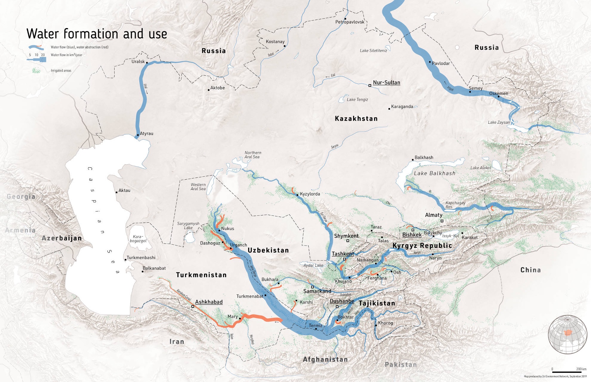
Figure 2.1: Map highlighting the Central Asian rivers network (rivers are shown in blue color). The dense river network in the mountainous areas starkly contrasts with the sparse one in the plains. Source: Zoï Environment Network.
All Central Asian river basins are endorheic with no water draining out of the region but only evaporating back to the atmosphere. This emphasizes the importance of moisture transfer as an important mechanism in the region region since the formation of substantial watercourses in the mountains is followed by their complete dissipation in the plains, including in the irrigated oases and the terminal lakes, i.e. the Aral Sea and Lake Balkash.
In the boreal summer, tropical air masses form in the plains of Central Asia. At that time, even cold air masses coming from the north heat quickly. There is no possibility for temperature differences between the lower and the middle troposphere to occur which explains the horizontal uniformity of high temperatures during summer.
Contrary to this, the temperature differences in the region are highest in January during the peak of the boreal winter. As the territory of Central Asia is unprotected from the north, it is under the influence of dry, exceptionally cold air masses originating from the Arctic region and Siberia. These air masses can cause sharp frosts. The further the Siberian or Arctic air masses penetrate towards the west and the south, the more their temperature increase. This explains the big difference in air temperatures during winter between the north and the south of Central Asia. Cold air intrusions are often accompanied by the influx of warm air from the tropics. The cold waves taking turns with hot air masses cause unsteady frost in the plains and, together with generally low precipitation values, do not allow for the formation of a significant snow pack there (Shults 1965).
//TODO: properly reference Section here. As is discussed further below, the winter snow cover in the high mountain ranges plays an essential role in runoff formation in the spring and summer months and is thus of key relevant to irrigation agriculture in the downstream and for hydropower production (see Section ~ below). Understanding the atmospheric mechanisms resulting in favorable conditions for winter precipitation is thus essential. With a warming climate and the associated increase of evapotranspiration in the downstream plains and the loss of glacier storage in the mountainous areas, a solid understanding of snow pack formation becomes even more pertinent.
(Gerlitz et al. 2018) discusses how the position of the westerly jet stream is connected with the frontal trajectories and the westerly disturbances which are the main moisture sources if the region. The relative position of these planetary wave tracks and their associated westerly flows to the orographic mountain barriers plays thus a key role. The main precipitation events migrate over the winter season from south to north. The southern parts of central Asia, particularly the windward slopes of the Karakorum and Hindu Kush mountain ranges, receive high amounts of winter precipitation (December-January-February), which reaches up to 60% of the total annual precipitation. During spring the zone of maximum precipitation migrates northward, reaches the Pamir plateau in March, and continues to Tien Shan in April/May. The interaction of tropical air masses from the Arabian Golf with westerly flow in Central Asia is another important moisture source for the region.
Using data of the ERA-Interim reanalysis, (Gerlitz et al. 2018) classifies 8 weather types (WT) based on typical regional pressure field patterns over a domain covering 20- 60N and 50- 90E. Like this, large-scale features of winter circulation patterns in Central Asia can be captured. WT are analyzed with regard to the spatial anomalies of temperature and precipitation. Figures 2.2 and 2.3 show results. In these Figures, the individual plates WT 1 - 8 are labeled according to the main circulation feature over Central Asia, i.e. a Rossby ridge (R) or trough (T).
Generally, it can be observed that configurations that are associated with a Rossby trough over Central Asia lead to an intensification of westerly moisture fluxes (WT 3, WT 7, and WT 8). If there is, however, a Rossby ridge type configuration as shown in WT 1, WT 2, and WT 4 panels of Figures 2.2 and 2.3, moisture fluxes are northward-shifted and precipitation suppressed (Gerlitz et al. 2018).
![Composite maps illustrating the averaged anomalies of ERA-Interim/Land 6-hourly temperature for each weather type (WT 1 - WT 8). Values are depicted in standard deviations for each grid cell, respectively. Arrows indicate anomalies of the 500-hPa ERA-Interim wind field [@gerlitz_2018].](_bookdown_files/FIG_HYDRO_SYSTEMS/fig_WT_T_Anomalies.png)
Figure 2.2: Composite maps illustrating the averaged anomalies of ERA-Interim/Land 6-hourly temperature for each weather type (WT 1 - WT 8). Values are depicted in standard deviations for each grid cell, respectively. Arrows indicate anomalies of the 500-hPa ERA-Interim wind field (Gerlitz et al. 2018).
Figure 2.3: Composite maps illustrating the averaged anomalies of ERA-Interim/Land 6-hourly precipitation sums for each weather type. Values are depicted relative to the seasonal mean 6-hourly precipitation sum ((100)-1) for each grid cell, respectively. Arrows indicate anomalies of vertically integrated moisture fluxes (Gerlitz et al. 2018).
Precipitation is extremely unevenly distributed in the region. 20% of the plain area receives less than 100 mm, while 91% of the territory receives less than 300 mm of precipitation a year with an overall average of 173 mm. The mountains are thus an important climatological and hydrological factor, since they are the places where the water condensates and where the rivers and groundwater originate. Although the range of precipitation levels is wide (60 mm - 2’500 mm), the mountains receive on average more than three times more precipitation than the plains, and the low temperatures favor its accumulation in the solid state (Shults 1965).
The influence of the relief is notable also when speaking of precipitation distribution during the year. The high ground areas in Central Asia are witnessing an almost even distribution of precipitation on monthly basis, whereas at the same time, in the inner parts of high mountain ridges there is more precipitation in summer. Such a distribution of precipitation in the inner parts of mountain ridges is a consequence of high condensation levels in summer due to intense evaporation taking place in snow melting areas or, less often, on water surfaces.
A typical example showing the influence of the local water vapor emission on annual distribution of precipitation could be the Issyk Kul Lake Basin. There the percentage of precipitation received during summer and the second half of spring, so from May to August, is sometimes reaching even 80% of the total annual precipitation amount, all thanks to the evaporation of the water from the lake and the emergence of thermal convection and subsequent moisture recycling.
The areas that are characterized by a predominant precipitation during summertime are the Central Tian Shan and Eastern Pamir, where the difference between the summer and the rest of the year is so big that during summer 60% of all annual precipitation is received.
The predominance of the precipitation during summer in case of mountains with steep slopes (15° - 30°) causes fast and abundant snowmelt runoff which is directed to the lower areas and then turns into a river network. Thanks to a large amount of precipitation, relatively low evaporation levels and steep slopes, all rivers of Central Asia, including the largest ones such as Amu Daria, Syr Daria, Ili or Zeravshan, arise in the mountains. Arising in the high ground area, these rivers are mainly fed by snow, glaciers and snow patches melting, as well as by groundwater that, again, were all formed by the same sources.
Due to the presence of the vertical thermal gradient, the start of the positive air temperature season, and consequently, the start of the ice and snow melting season does not take place at the same time uniformly. Rather, the snow melting process is of protracted nature and the higher the mountains are in a particular catchment, the later the snow-melt floods take place on rivers that are emerging there.
The melting process starts last in the permanent snow and glaciers regions. Because of this, the rivers, which are fed by snowmelt in the upper parts of the catchment area, are of great importance for the irrigation of crop fields, since they are characterized by the most significant water runoff during July and August, at which point the irrigated plains experience severe drought and when irrigated crops have the highest water demand.
The rivers having this kind of a runoff regime (nivo-glacial) are Pyandzh and Vakhsh Rivers, as well as the ones deriving from them, such as Amu Darya, Chu, Zeravshan, Talas and Ili Rivers with its numerous tributaries. These rivers all feature a small variability of annual runoff. This is partly a result of the regulating effect of the zone of eternal snows and ice and is very important from the perspective of agricultural production in the downstream. These rivers are thus particularly valuable, not only for irrigation but also as a source of hydroelectric power.
Rivers originating from the low mountains but being fed mainly by the snowmelt (nival regime rivers), are characterized by the early floods (March-May) and a sharp variability of annual runoff, since the amount of water is almost entirely determined by the snow reserves in the mountains which were accumulated in the previous winter season.
Finally, the watercourses originating from the lowest parts of mountains or from low mountains, (nivo-pluvial regime rivers), which in comparison to other regimes receive much more liquid precipitation, are characterized by large amounts of water, often saturated by sediment, passing during short periods of time. These are so-called mudflows. These watercourses often dry up during summer because of a decrease in supplies from groundwater.
When entering the plains, the rivers of Central Asia form wide-spreading alluvial fans consisting of materials brought by them from the mountains. Here the rivers are usually divided into several channels, and a large part of water is filtered by these sediments. The large quantities of groundwater in these alluvial fans, which appear due to this process, mostly protrude from the earth surface at the edges these alluvial fans, causing the small rivers that are fed by groundwater, so-called Karasu rivers, to emerge, which are also used for irrigation.
The relief thus has an extremely strong and many-sided impact on runoff formation processes. This influence is mediated through climatic factors, on which the recharge of the rivers, as well as the processes of thawing of snow and ice, etc., depend. In this regard, both the average water content, consistency of the annual runoff and its distribution over a year, as well as other characteristics of the river runoff cannot be considered independently from key relief factors, first and foremost altitude. All this demands a careful and comprehensive analysis of the impact of the relief on runoff processes.
namely the distribution of sand and loess relief types, where the former are more permeable and the latter contain more moisture↩︎