2.3 Runoff Formation
The process of runoff formation is critically determined by the generation of direct runoff from liquid precipitation and the melting of snow and ice over the course of a hydrological year. Considering carefully the individual components for basins under consideration is important in order to properly understand the runoff regimes of individual rivers and for conceptualizing key processes for mathematical modeling.
![Map of the upper Syr Darya and Amu Darya catchments. The catchments are outlined. Colors encode topographic height. Basin outlets (red dots) are chosen to correspond to the confluence of the two main rivers for each catchment. Topographic data is from [@USGS_2020].](_bookdown_files/FIG_HYDRO_SYSTEMS/fig_AmuSyrDarya.png)
Figure 2.4: Map of the upper Syr Darya and Amu Darya catchments. The catchments are outlined. Colors encode topographic height. Basin outlets (red dots) are chosen to correspond to the confluence of the two main rivers for each catchment. Topographic data is from (“Srtmgl1 n -ASA SRTM Version 3.0” 2020a).
First, we study the role of glacier melt. For this, it is instructive to start to look at the condition of discharge formation in the Amu Darya and Syr Darya basins (see Figure 2.4). More specifically, we compare the two main subcatchments of the Vakhsh and Pyandzh Rivers in the Amu Darya and the Naryn and Kara Darya catchments in the Syr Darya3. In the first two reservoirs, the mountains exceeding 5’000 m occupy 6.2% of their area, and the mountains higher than 4’000 m — 42%, in case of reservoirs of the second two rivers, the mountains exceeding 5’000 m occupy less than 1% of their area and the ones with altitudes over 4’000 m — only 4%. Figure 2.5 shows the basins’ hypsographic curves.
Even if we take into account that in the case of the basins of Pyandzh and Vakhsh the snow line is on average located at the height of 4’600 m — 4’500 m and in case of the basins of Naryn and Kara Darya at 4’000 m - 3’900 m, 19% — 22% of the reservoirs of Pyandzh and Vakhsh is located above the snow line, and in case of reservoirs of Naryn and Kara Darya it is only 4% — 5%. The role of glaciers in the annual distribution of runoff is thus more substantial in the case of the Amu Darya as compared to the Syr Darya. And to come to an informed conclusion, one has to take into account all land ice features, including their altitude.
![Hypsographic curves of the upper Syr Darya and Amu Darya catchments. The SRTM topographic model was used for the calculation of the curves [@USGS_2020].](_bookdown_files/FIG_HYDRO_SYSTEMS/fig_AmuSyrDarya_HypsographicCurves.png)
Figure 2.5: Hypsographic curves of the upper Syr Darya and Amu Darya catchments. The SRTM topographic model was used for the calculation of the curves (“Srtmgl1 n -ASA SRTM Version 3.0” 2020a).
Data on land ice can be obtained from the Global Land Ice Measurements from Space glacier database GLIMS (GLIMS and NSIDC 2005, updated 2018). The Global Land Ice Measurements from Space (GLIMS) project at NSIDC has implemented a database of glacier outlines from around the world and other information about glaciers that includes the metadata on how those outlines were derived. At <www.glims.org>, one can download outlines and metadata for glaciers in a choice of different formats, including KML (for viewing in Google Earth), ESRI shapefiles, GMT (Generic Mapping Tools), MapInfo, or GML (Geography Markup Language). Figure 2.6 shows a sample visualization of the GLIMS data for the zone of runoff formation of the Amu Darya. The data will also be utilized in Chapter @ref(#HydrologicalSystems) below to obtain good ideas of the subcatchments’ glaciation levels.
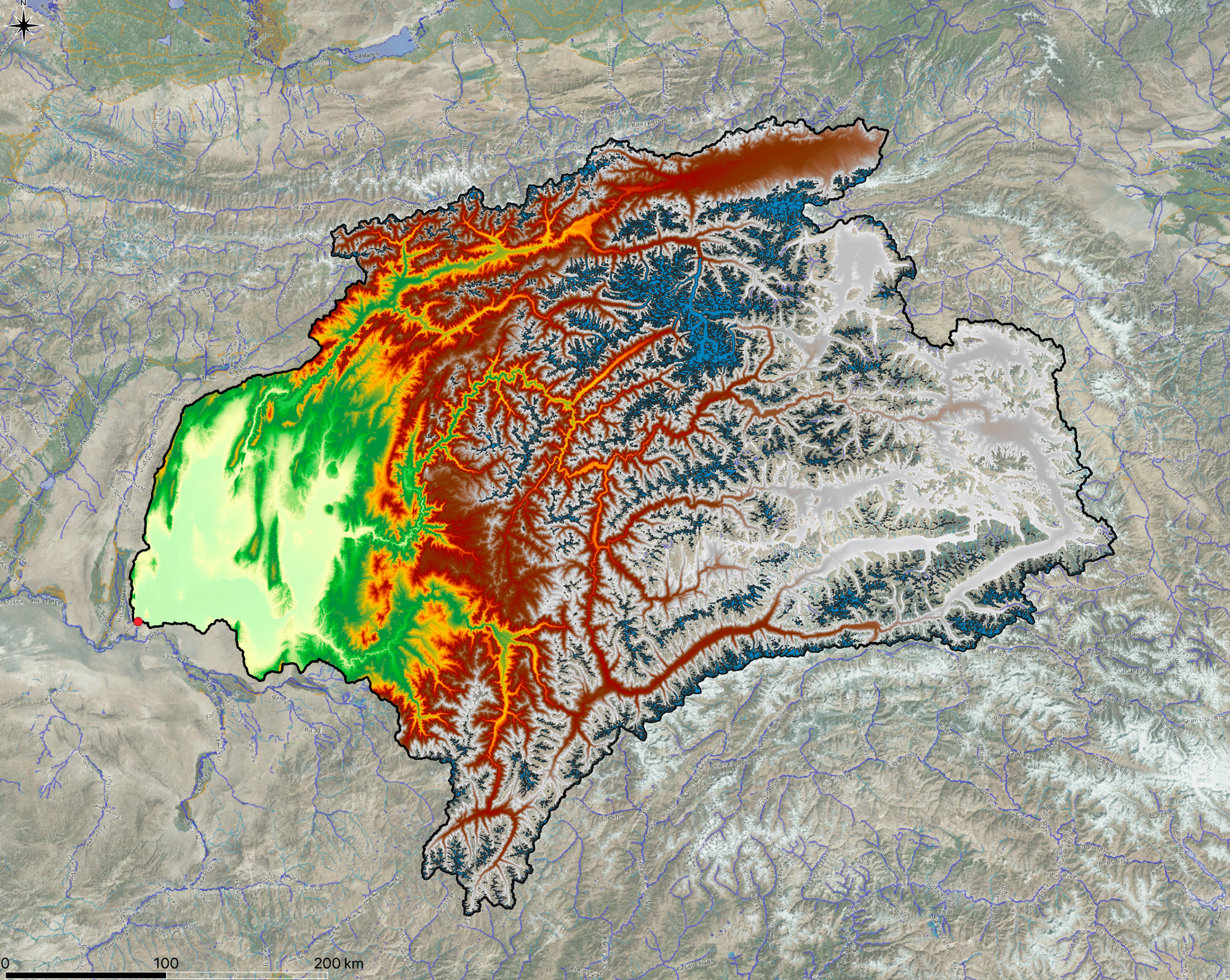
Figure 2.6: Visualization of the GLIMS data glaciation in the Vaksh-Pyandzh basin. The light blue shaded polygons show land ice on top of the underlying digital elevation model.
Figure 2.7 shows the distribution of mean glacier elevations of the Randolph Glacier Inventory 6.0 dataset in the GLIMS database. The center of mass for the Amu Darya is at 4’827 masl whereas it is at 4’110 masl for the Syr Darya.
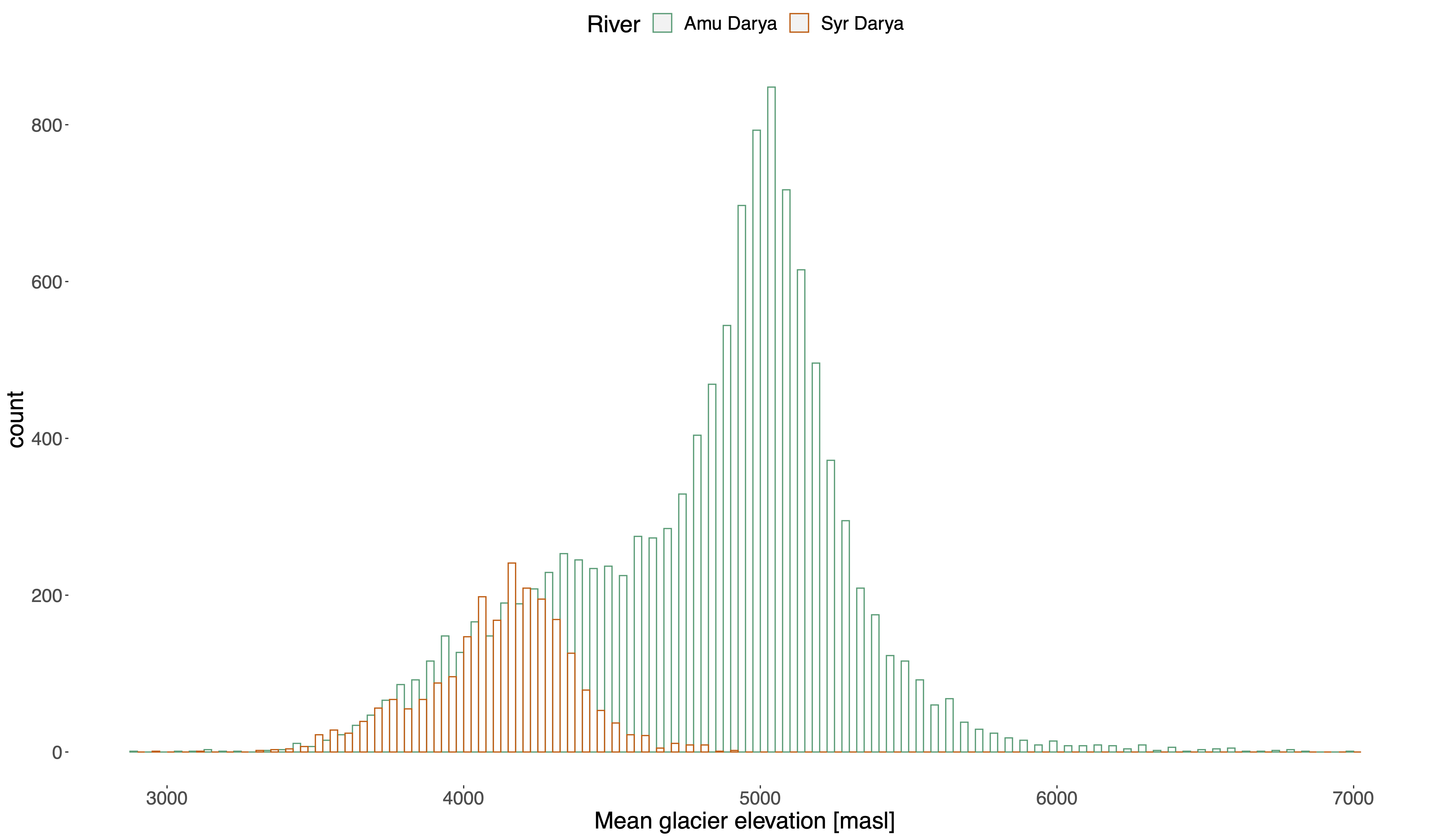
Figure 2.7: Distribution of mean glacier elevations as extract from the GLIMS database. Only data from the Randolph Glacier Inventory 6.0 was used as subset of the complete GLIMS record. For the computation of the mean elevation, SRTM data was utilized.
Since the GLIMS database contains contains the shapes of glaciers as geometric features, we can easily calculate areas that the individual glaciers cover and then utilize scaling relationships between surface area and volume to estimate total ice storage in the individual Central Asian catchments. Aizen, Aizen, and Kuzmichonok (2007) report such scaling relationship for the Central Asian region. As a function of glacier area, they are
\[ V = 0.03782 S^{1.23} \text{ for } S< 0.1 \text{ km}^2 \\ V = \frac{0.03332 S ^ {1.08} e^{0.1219 L}}{L^{0.08846}} \text{ for } 0.1 < S < 25 \text{ km}^2 \\ V = 0.01848 S + 0.021875 S^{1.3521} \text{ for } S > 25 \text{ km}^2 \]
where \(S\) is the area of a glacier, \(L\) the length of the glacier and \(V\) the computed volume from the scaling relationship. The length \(L\) of the individual glaciers can be approximated by subtracting the minimum glacier elevation from the corresponding maximum elevation. Like this, we can compute land ice volumes of the Amu Darya and Syr Darya basins in an approximate yet scientific way.
Alternatively, we can use the much simpler volume area scaling relationship as reported by Erashov (Erasov 1968).
\[ V = 0.027 * S^{1.5} \] where again, \(S\) is the area of the glaciers in km2 and \(V\) is the computed volume using the simple scaling relationship.
(The emerging river after the confluence of the Vakhsh and Pyandzh rivers is called Amu Darya whereas the Syr Darya emerges after the confluence of the Naryn and Kara Darya rivers.)↩︎